The Indian Ocean
Gravity Anomaly Maps
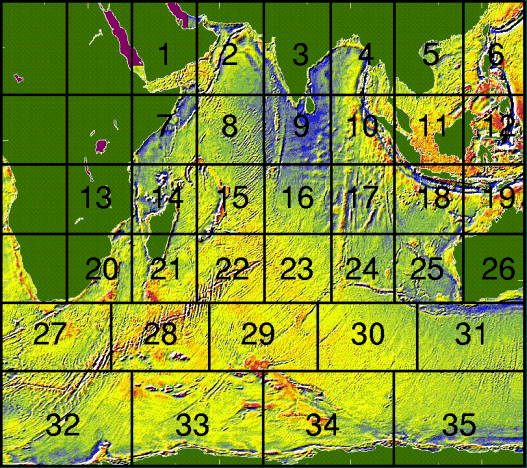
In this overview map the separate maps are shown.
The numbers correspond to the list of areas below.
Click in the overview map above or on an area name in the
index below in order to get a detailed (but
small) map of the area; large maps (1280 by 1024
pixels) are also available.
All maps overlap at least 5 degrees so the actual map
boundaries differ slightly from the boundaries in the
overview map above.
1 Gulf of Aden
2 Arabian Sea
3 Indian coast
4 Bay of Bengal
5 South China Sea
6 Philippine Sea
7 Somali Basin
8 Central Indian Ocean Ridge (north)
9 Chagos-Maldive-Laccadive Ridge
10 Ninety-East Ridge (north)
11 Java Sea
12 Banda Sea
13 Mozambique Channel
14 Madagascar (north)
15 Central Indian Ocean Ridge (south)
16 Chagos
17 Ninety-East Ridge (south)
18 Java Trench
19 Timor Sea
20 Natal
21 Madagascar (south)
22 South-West Indian Ridge
23 Indian Ocean Triple Junction
24 Broken Ridge
25 Wallaby Scarp Fracture Zone
26 Perth
27 Agulhas Plateau
28 Crozet Basin
29 Kerguelen Island
30 South East Indian Ridge
31 Diamantina Discontinuity
32 Dronning Maud Land
33 Enderby Basin
34 Kerguelen (south)
35 Wilkes Basin
 The Altimetry Atlas opening page