


Next: Orbital differences Up: Results Previous: Altimeter height residuals
Crossover height differences
Crossover height differences are the best indicator of the radial orbit error. Although part of it should be contributed to actual sea level change, altimeter noise, and correction errors, the global RMS of the crossover height differences ( ) is primarily determined by the
RMS
radial orbit error difference at crossover points. If the orbit
errors at the crossing points of each ascending and descending pass were
completely uncorrelated, could be equally divided over both
passes, leading to a radial orbit error estimate of
) is primarily determined by the
RMS
radial orbit error difference at crossover points. If the orbit
errors at the crossing points of each ascending and descending pass were
completely uncorrelated, could be equally divided over both
passes, leading to a radial orbit error estimate of
 for all passes.
However, gravity field model errors induce regional vertical offsets of the
orbit that are constant from repeat cycle to repeat cycle, and may be
common to both the ascending and descending pass. Thus, a considerable part
of the gravity-induced radial orbit error is purely geographically
correlated and can not be observed from crossover height differences. But
also other statistical analyses (orbital differences, altimeter height
residuals, collinear track analyses) do not provide any information on this
part of the radial orbit error. This phenomenon is known as the
non-observability of the geographically-correlated radial orbit error.
Estimates for this contribution thus comes from statistical analyses
of the estimated gravity model error (See Section  ).
).
Figure 6 : Distribution of crossovers and their height difference statistics based on OPR02 Cycle 9 and the DUT JGM-2 orbits. The values are the RMS crossover difference (in cm) for each 20
 x 20
cell with at least 20 crossovers.
Crossover height differences exceeding 3.5 times the global RMS value of
20.2 cm did not contribute to the statistics.
x 20
cell with at least 20 crossovers.
Crossover height differences exceeding 3.5 times the global RMS value of
20.2 cm did not contribute to the statistics.

Figure 6 displays the global distribution of the 50,143
crossovers that could be generated from the edited OPR02 data sets for
Cycle 9. This Figure also presents the RMS crossover height difference
per 20 x 20
cell, based on the operational DUT orbits. In
order to eliminate spurious data, editing at a level of 3.5 times the
global crossover RMS of 20.2 cm was applied.
Some higher crossover differences are influenced by sea level variability caused by strong meandering and variable currents, like the Circumpolar Current, Kuroshio, and Gulf Stream. Generally, at higher latitudes, the crossover RMS is higher than over equatorial regions (See also Figure 7).
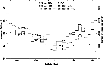 Figure 7:
Crossover height difference RMS as a function of their geodetic latitude.
The crossovers are based on the D-PAF orbit (dotted line),
DUT JGM-2 operational orbit (continuous line), or the JGM-2 orbit including
SLR and ERS-1/TOPEX crossovers as tracking data (dashed line).
Dots indicate the number of crossovers per bin.
Figure 7:
Crossover height difference RMS as a function of their geodetic latitude.
The crossovers are based on the D-PAF orbit (dotted line),
DUT JGM-2 operational orbit (continuous line), or the JGM-2 orbit including
SLR and ERS-1/TOPEX crossovers as tracking data (dashed line).
Dots indicate the number of crossovers per bin.
This might be due to a remaining local degradation of the radial orbit
error, but meandering of currents, and the resulting sea level variability,
should not be excluded as a cause. In coastal regions, imperfection in the
modelling of tides contribute to a regional increase of the crossover
height differences. At very high latitudes (above 60
North and below 60
South), errors in the atmospheric corrections and
interference by ice sheets will strongly affect the statistics. Low values
like in the Eastern Pacific Ocean, where no sizable currents are present,
are most indicative of the real radial orbit errors.
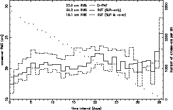
Figure 8: Crossover height difference RMS as a function of the time interval between the ascending and descending pass forming each crossover. The crossovers are based on the D-PAF orbit (dotted line), DUT JGM-2 operational orbit (continuous line), or the JGM-2 orbit including SLR and ERS-1/TOPEX crossovers as tracking data (dashed line). Dots indicate the number of crossovers per bin.
Figure 8 portrays the distribution of the crossover RMS as a function of the time laps between the ascending and descending passes forming the crossover.
The crossover RMS , however, shows a significant increase during the first ten days, and then stabilises. The RMS values start out with 17-18 cm for a time interval less than 2 days, and increase to an average of 20-23 cm for intervals longer than ten days. The discrepancy of 12-14 cm (in RSS sense) is likely to be caused by ocean variability, propagation correction errors, and tide model errors. All these have decorrelation periods of some 2 to 10 days, and thus contribute to the crossover height differences only at longer time intervals. The magnitude of the discrepancy is compatible with generally accepted values of 6, 4, and 4 cm for the ocean variability, tide model errors, and propagation correction errors, respectively.
Next: Orbital differences Up: Results Previous: Altimeter height residuals